Freezing levels are one of the most practical weather concepts a pilot can understand during flight planning. The freezing level is the altitude where the outside air temperature reaches 0 degrees Celsius, but its operational meaning goes far beyond a number on a weather chart. For a pilot, that altitude helps frame questions about cloud layers, precipitation, structural icing risk, escape options, aircraft performance, and whether a proposed route offers enough margin for the aircraft and crew.
Good flight planning is not simply finding the freezing level and deciding whether the airplane will be above or below it. The atmosphere is layered, uneven, and constantly changing. Freezing levels can slope across a route, rise and fall with weather systems, and sometimes occur more than once in the same vertical column of air. A thoughtful pilot uses freezing level information as one part of a broader weather picture that includes moisture, cloud bases and tops, fronts, precipitation, winds aloft, pilot reports, icing forecasts, and the aircraft’s equipment and certification. This article explains how to interpret freezing levels in practical terms and how to make better go, no-go, and reroute decisions when cold-weather flight planning becomes complicated.
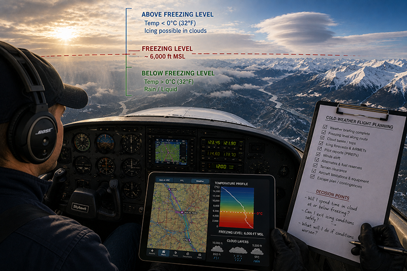
What the Freezing Level Means
The basic definition is straightforward: the freezing level is the altitude in the atmosphere where the temperature is 0 degrees Celsius. Above that level, the air is often colder than freezing. Below it, the air is often warmer than freezing. In a standard, simplified atmosphere, temperature generally decreases with altitude, so pilots often picture a single clean boundary. Real weather is rarely that tidy.
The freezing level does not mean that ice will automatically form at that altitude. Ice formation requires more than cold air. For aircraft structural icing, the key concern is supercooled liquid water, which is liquid water existing at temperatures below freezing. If an aircraft flies through visible moisture such as cloud, freezing drizzle, freezing rain, or certain precipitation while the aircraft surfaces are cold enough, ice can accrete on wings, tail surfaces, propellers, antennas, windshields, and other exposed areas. A freezing level provides the temperature context, but moisture determines whether icing is likely to become an operational hazard.
It is also important to understand that the freezing level is normally reported or forecast as an altitude, often in feet above mean sea level. A pilot departing from a high-elevation airport may have much less vertical room between the ground and the freezing level than a pilot departing from a coastal airport. In mountainous terrain, terrain elevation can reach into or above the freezing level, which makes cloud clearance, icing avoidance, and escape planning more demanding.
Freezing levels are commonly considered along with cloud bases and tops. If the freezing level is 6,000 feet and the cloud layer extends from 3,000 to 9,000 feet, a portion of that cloud exists in subfreezing air. A non-icing-approved aircraft operating through that portion may be exposed to structural icing if supercooled liquid water is present. If the same freezing level exists but the route is clear below a scattered layer well above the planned altitude, the operational concern may be much lower. The freezing level matters most when it is connected to the rest of the weather environment.
Why Freezing Levels Matter in Real-World Aviation
Freezing levels affect several parts of flight planning at once. The most obvious connection is icing, but the concept also influences route selection, altitude planning, fuel strategy, alternates, terrain clearance, and emergency options. A pilot who treats freezing level information as a simple weather trivia item can miss the operational implications. A pilot who integrates it into the full weather decision builds a more realistic plan.
For VFR pilots, freezing levels matter because marginal weather can become more restrictive when cloud layers sit near or below freezing temperatures. A planned route under a cloud deck may appear workable until terrain rises, ceilings lower, or precipitation develops. A climb through a layer may not be a safe option if the layer contains icing conditions and the aircraft is not equipped and approved for flight in known icing. Even when the airplane remains below the freezing level, cold rain, low ceilings, and lowering visibility can reduce practical escape options.
For IFR pilots, freezing levels are central to the altitude decision. The most efficient altitude is not always the safest altitude. An IFR clearance may place the aircraft in cloud at temperatures supportive of icing, while a lower or higher altitude might offer a safer ride if terrain, airspace, performance, and ATC allow. In some cases, climbing above a cloud layer can be a reasonable strategy if aircraft performance and cloud tops support it. In other cases, the tops are too high, the climb would take too long, or the airplane would spend too much time in icing conditions during the transition.
For flight instructors, freezing levels are a valuable teaching tool because they force students to connect weather theory with practical aeronautical decision-making. A student may know the definition of icing and the freezing level, yet still struggle to answer the operational question: Where will the airplane be relative to clouds, precipitation, terrain, and escape routes? Training should move beyond memorizing weather symbols and toward building a mental model of the atmosphere along the proposed route.
For commercial operators and aviation professionals, freezing level analysis supports dispatch judgment, passenger expectations, fuel planning, and contingency management. Even when operating aircraft approved for certain icing conditions, pilots still need to respect aircraft limitations, performance penalties, and the difference between certification capability and good operational judgment. Anti-ice and deice systems are not a license to ignore changing weather. They are tools that must be used within the aircraft’s procedures and limitations.
How Pilots Should Understand Freezing Levels
A practical way to understand freezing levels is to think in layers. First, identify the expected temperature profile along the route. Second, compare that profile to the planned altitude, minimum safe altitudes, and likely ATC altitudes. Third, add moisture by looking at clouds, precipitation, frontal activity, and pilot reports. Fourth, decide what escape options exist if the forecast is wrong or conditions worsen.
The first layer is the temperature profile. Pilots can review winds and temperatures aloft forecasts, graphical weather tools, freezing level charts, icing forecasts, and aviation weather briefings to develop a vertical picture of the atmosphere. The goal is not to find a single perfect number. The goal is to identify where temperatures transition from above freezing to below freezing and whether the planned flight will spend time in the altitude band where icing is plausible.
The second layer is moisture. A freezing level without moisture is usually not an icing problem for the airframe, although other cold-weather hazards may still exist. Moisture changes the picture. Clouds, precipitation, frontal zones, and saturated layers can create conditions where supercooled liquid water is present. The phrase visible moisture is useful because it reminds pilots that cloud and precipitation are the environments where structural icing concerns become operationally significant.
The third layer is time. A brief encounter with light icing is not the same as a long cruise segment embedded in cloud at subfreezing temperatures. Exposure time matters because ice accretion can build, aircraft performance can deteriorate, and workload can increase. A flight plan that requires prolonged travel through a cold saturated layer should be evaluated very differently from one that remains in visual conditions with a short, well-planned climb or descent through a shallow layer.
The fourth layer is aircraft capability. A training aircraft with no ice protection, a high-performance piston aircraft with limited ice protection, and a turbine aircraft with approved systems may all face the same freezing level, but their practical options are different. Pilots must understand the aircraft flight manual, placards, operating procedures, and limitations applicable to their specific aircraft. General weather knowledge cannot substitute for aircraft-specific limitations and procedures.
The fifth layer is exit strategy. Before accepting a route or altitude near the freezing level in cloud or precipitation, the pilot should know how to leave the hazard. That may mean descending to warmer air, climbing above cloud tops, turning around, diverting, or requesting a different altitude or route. The best escape plan is one that is realistic before the airplane enters the problem, not one invented after ice has already formed.
Single, Multiple, and Sloping Freezing Levels
Many pilots first learn freezing level concepts as if there is one freezing level at one altitude. In reality, the atmosphere can produce more complex temperature structures. A single freezing level is common when temperature generally decreases with altitude. However, temperature inversions can create multiple freezing levels, where a layer of warmer air exists above a colder layer. This matters because precipitation can fall through different temperature layers and change form along the way.
Multiple freezing levels can be especially relevant when freezing rain or freezing drizzle is possible. A warm layer aloft may melt falling precipitation into liquid drops, then a shallow subfreezing layer near the surface may allow those drops to become supercooled before impact. This type of setup can create serious surface and airborne icing concerns. Pilots should treat any indication of freezing rain or freezing drizzle with particular caution, especially in aircraft not approved and equipped for such conditions.
Freezing levels can also slope across a route. A departure airport may have a freezing level at one altitude, while the destination or en route terrain may have a different value. A cold front, warm front, coastal influence, mountain range, or changing air mass can create substantial horizontal variation. For cross-country planning, the question is not simply, What is the freezing level at departure? The better question is, How does the freezing level change along the entire route and during the planned time of flight?
Time of day can also matter. Solar heating, nighttime cooling, warm advection, and frontal movement can shift temperatures during the flight window. A morning departure may encounter a different freezing level profile than an afternoon return. Pilots should avoid assuming that a freezing level observed or forecast earlier in the day remains valid for the whole operation.
Connecting Freezing Levels to Icing Risk
Freezing level analysis is not the same as icing forecasting, but it is an essential part of it. Structural icing generally requires an aircraft to be in visible moisture with aircraft surfaces at or below freezing. The atmosphere can contain supercooled liquid water at temperatures below 0 degrees Celsius, and when those droplets strike the aircraft, they can freeze and accumulate. The severity, type, and rate of icing depend on temperature, droplet size, liquid water content, aircraft shape, speed, and exposure time.
When pilots review freezing levels, they should ask whether the planned altitude intersects with visible moisture. If the freezing level is below the cloud base, much of the cloud may be in subfreezing air. If the freezing level is within the cloud layer, the lower portion may be warmer while the upper portion may be colder. If the freezing level is above the cloud tops, structural icing risk within that particular cloud layer may be reduced because temperatures are likely above freezing, but pilots should still evaluate the entire weather picture and any precipitation processes involved.
Precipitation adds another layer of complexity. Snow at altitude, rain below a warm layer, freezing rain, and mixed precipitation can all reveal important details about the temperature profile. A surface observation reporting rain with a temperature near freezing, or any report of freezing precipitation, deserves careful attention. A route that appears acceptable based only on a freezing level number may become unacceptable when precipitation type and cloud structure are considered.
Pilot reports can be extremely helpful because they describe what aircraft are actually encountering. Reports of cloud tops, bases, icing, and temperatures aloft can confirm or challenge the forecast. However, a lack of icing reports does not prove the absence of icing. Traffic may be sparse, aircraft may be operating at different altitudes, or conditions may change quickly. Use pilot reports as valuable evidence, not as a guarantee.
Using Weather Products Without Overtrusting Any One Product
Modern pilots have access to excellent weather information, but the abundance of tools can create a false sense of precision. Freezing level charts, graphical aviation forecasts, icing forecasts, winds and temperatures aloft, surface observations, terminal forecasts, area forecasts, radar, satellite, and pilot reports all contribute to the picture. Each product has strengths and limitations. The skilled pilot compares products rather than relying on one display.
A freezing level graphic may show a broad regional pattern, but it may not capture localized terrain effects or fast-moving frontal changes. Winds and temperatures aloft can provide forecast temperatures at standard altitudes, but the actual temperature at a specific point and time may differ. AIRMETs for icing can highlight broad areas of concern, but they do not mean icing exists at every altitude everywhere inside the area. Likewise, the absence of an advisory does not remove the pilot’s responsibility to evaluate temperature, moisture, and aircraft capability.
Onboard datalink weather can help pilots monitor trends, but it should not be treated as real-time tactical weather avoidance for all hazards. Weather products displayed in the cockpit can be delayed, simplified, or limited by coverage and product design. The cockpit display is best used to support strategic decisions such as diversion planning, altitude requests, or route changes, not to press deeper into deteriorating conditions without an exit.
The best habit is to build a weather story. Where is the cold air? Where is the moisture? Where are the clouds and tops? What are other pilots reporting? How is the system moving? What happens if the freezing level is lower than forecast? When pilots reason this way, freezing level data becomes part of a robust decision rather than a single number used in isolation.
Common Mistakes and Misunderstandings
One common mistake is assuming that being below the freezing level eliminates all cold-weather concerns. If the aircraft remains in above-freezing air, structural ice accumulation is generally less likely, but the flight may still face low ceilings, poor visibility, cold rain, high terrain, turbulence, or limited escape options. In addition, temperature can decrease during a climb, along the route, or near higher terrain. A plan that is safe at one point may not remain safe for the entire flight.
Another mistake is assuming that being above the freezing level automatically means icing will occur. Cold air alone is not enough. The airplane must encounter the right moisture conditions for structural icing. Clear air at subfreezing temperatures can be uneventful from an airframe icing standpoint, although pilots must still consider fuel temperature, engine operation, oxygen requirements, and aircraft-specific procedures where applicable.
A third misunderstanding is treating the freezing level as a hard, flat boundary. Forecast freezing levels are approximations. The actual atmosphere may include pockets of warmer or colder air, vertical motion, inversions, and localized effects. A pilot who plans to cruise only a few hundred feet below a forecast freezing level while in cloud may have little margin if the forecast is off or the terrain rises.
Some pilots also focus only on the cruise segment. Departure and arrival phases can be more constrained because altitudes are dictated by terrain, procedures, airspace, and ATC. A route may look manageable at cruise altitude, but the climb or descent may require extended time in a cloud layer below freezing. Approach segments in cold, wet weather can be especially demanding because workload is high, configuration changes are occurring, and there may be limited time to respond to ice accumulation.
Finally, pilots sometimes overestimate the capability of ice protection equipment. Aircraft systems vary widely. Some equipment is intended to remove ice after accumulation, some is intended to prevent ice formation on protected surfaces, and some aircraft have no certified capability for known icing conditions. Even approved systems have procedures, limitations, and performance considerations. The presence of boots, heated propellers, or heated pitot systems should never be interpreted as permission to ignore adverse icing forecasts or fly beyond the aircraft’s approved envelope.
Practical Example: Planning a Winter IFR Cross-Country
Consider a pilot planning an IFR cross-country in a normally aspirated piston airplane on a winter morning. The departure airport is at low elevation, the destination is beyond a line of rising terrain, and the proposed cruise altitude is 8,000 feet. The weather briefing shows a broken cloud layer from about 4,000 to 7,000 feet along part of the route, with tops reported near 8,500 feet in some areas. The freezing level is forecast near 5,000 feet at departure and closer to 3,500 feet near the destination. Light precipitation is possible near the destination.
A superficial plan might focus on the fact that cruise is near the tops and assume the airplane can climb through the layer. A more disciplined plan asks better questions. How long will the aircraft be in cloud between 5,000 and 8,000 feet? Are there reports of icing in that layer? Are the cloud tops consistent or variable? Can the airplane climb above the tops with adequate performance and oxygen considerations if needed? Is there warmer air below the clouds that still provides terrain clearance? What alternates are available before the terrain rises? What will the descent look like at the destination if the freezing level is lower there?
In this scenario, the freezing level is not a single go or no-go answer. It is a warning that the cloud layer intersects with subfreezing temperatures. If pilot reports indicate ice in the climb, if cloud tops are higher than expected, or if terrain prevents a descent into warmer air, the risk increases. A safer decision might be to delay until the layer lifts or temperatures warm, select a lower route with better terrain and weather margins, choose a different destination, or cancel if the aircraft is not suitable for the conditions.
This example also shows why freezing level planning must cover the entire route. The destination has a lower freezing level than the departure area, and precipitation is possible. A pilot who only checks departure weather may miss the higher risk environment near arrival, when workload is already elevated and fuel reserves may be more relevant.
Best Practices for Pilots
The best freezing level decisions begin with conservative weather interpretation. Pilots should look for margins rather than minimums. If the aircraft is not approved for flight in known icing, the plan should avoid conditions where icing is expected or likely. If the aircraft is approved and equipped, the pilot still needs a practical strategy to minimize exposure, monitor accumulation, and exit conditions that exceed expectations or aircraft capability.
Before departure, compare the freezing level to the planned altitude, cloud bases, cloud tops, terrain, and minimum IFR altitudes. Think about the climb and descent, not only cruise. Identify warmer air below and clear air above, if either exists. If the only escape path requires climbing through an unknown thickness of icing cloud in an underpowered aircraft, that is not a robust plan. If descending to warmer air would put the aircraft below minimum safe altitude or into terrain concerns, the escape option may not be available.
Use pilot reports actively. A recent report from a similar aircraft near the same route and altitude is valuable, especially if it includes temperature, cloud tops, and icing intensity. But do not let the absence of reports create false confidence. Ask ATC for ride reports and icing reports when appropriate. Provide accurate pilot reports yourself when workload permits, because those reports help other pilots and forecasters understand the actual conditions.
During flight, monitor outside air temperature, visible moisture, aircraft performance, control feel, windshield and airframe cues, and any ice protection indications or procedures applicable to the aircraft. If ice begins to accumulate, act early. Small delays can reduce options, particularly in aircraft with limited climb performance. Request a different altitude, turn back, divert, or exit visible moisture as appropriate. The safest decision is often the one made before the situation becomes urgent.
- Evaluate freezing levels along the entire route, including departure, climb, cruise, descent, and alternate airports.
- Connect temperature information with visible moisture, cloud layers, precipitation type, and pilot reports.
- Maintain an escape plan that is realistic for the aircraft, terrain, airspace, and weather.
- Respect aircraft-specific limitations and procedures for ice protection, deicing, anti-icing, and prohibited conditions.
- Build extra margin when forecasts show frontal systems, precipitation, mountain terrain, or multiple freezing levels.
Training Value for Student Pilots and Instructors
Freezing level training should be scenario based. Students should practice reading weather products and then explaining the operational meaning in plain language. Instead of asking only, What is the freezing level? instructors can ask, Where is the airplane relative to the freezing level during climb? What cloud layers are present? Where is the nearest warmer air? What would make this flight unacceptable in our aircraft?
For private pilot students, the focus may be recognizing hazardous combinations and making conservative VFR decisions. For instrument students, the training should include altitude selection, icing forecast interpretation, ATC communication, alternate planning, and workload management during approaches in cold weather. For commercial and flight instructor candidates, the emphasis should expand to risk management, passenger briefing, operational discipline, and teaching freezing level concepts without oversimplifying them.
A helpful classroom exercise is to compare two routes on the same winter day. One route may have a lower freezing level but dry air and clear skies. Another may have a slightly higher freezing level but widespread cloud and precipitation. Students quickly learn that the higher freezing level is not automatically safer and that moisture and exposure time are decisive factors. This kind of training builds judgment rather than rote memorization.
Frequently Asked Questions
What is the freezing level in aviation?
The freezing level is the altitude where the outside air temperature is 0 degrees Celsius. Pilots use it to understand where temperatures become cold enough to support icing when visible moisture is present.
Does flying above the freezing level always mean icing?
No. Icing generally requires visible moisture and suitable temperatures, not cold air alone. Clear air above the freezing level may not produce structural icing, but pilots still need to evaluate the full weather situation and aircraft procedures.
Can there be more than one freezing level?
Yes. Temperature inversions and layered air masses can create multiple freezing levels. This is important because precipitation may pass through warm and cold layers, sometimes creating freezing rain or other hazardous mixed precipitation conditions.
How much margin should pilots keep from the freezing level?
There is no universal margin that applies to every aircraft, route, and weather situation. A prudent pilot considers forecast uncertainty, cloud layers, terrain, aircraft capability, and escape options rather than relying on a fixed distance from the freezing level.
Which weather information helps evaluate freezing levels?
Useful information includes freezing level forecasts, winds and temperatures aloft, graphical aviation forecasts, icing forecasts, AIRMETs for icing, METARs, TAFs, radar, satellite, and pilot reports. The strongest decisions compare several products rather than relying on one source.
What should a pilot do if ice begins accumulating in flight?
The pilot should follow the aircraft’s approved procedures and work promptly to exit the icing environment. Depending on the situation, that may involve requesting a different altitude, turning around, diverting, or leaving visible moisture while maintaining terrain and traffic clearance.
Key Takeaways
- The freezing level is a planning tool, not a complete icing forecast. It becomes operationally meaningful when combined with moisture, clouds, precipitation, terrain, and aircraft capability.
- Freezing levels can vary along a route and may occur in multiple layers, so pilots should evaluate the entire flight from departure through alternate planning.
- Sound cold-weather decision-making depends on margins, escape options, aircraft-specific limitations, and a willingness to delay, divert, or cancel when the weather picture is unfavorable.